File:WRF rita spread2.jpg
Jump to navigation
Jump to search
Size of this preview: 311 × 504 pixels.
Original file (311 × 504 pixels, file size: 51 KB, MIME type: image/jpeg)

Summary
| Description |
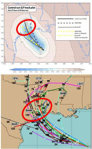
English: (Top): WRF model simulation of Hurricane Rita tracks. The model resolution is 30km. The colored field shows the lowest sea-level pressure (SLP) recorded during the last 27 hours of a 54 hour control simulation of Rita using LFO (5 class) microphysics and the Kain-Fritsch (KF) convective scheme. The superposed black line traces the model hurricane, which strikes Houston. Also shown are tracks of minimum SLP for runs using the Kessler (warm rain) scheme, the WSM3 simple ice scheme (with the Betts-Miller-Jancic convective scheme), the Kessler with reduced rain fallspeed, and WSM3 with enhanced ice fallspeed. (Bottom): The spread of NHC multi-model ensemble forecast at 06 UTC, 22 September. Note a similar ensemble spread was obtained from a single model simply by varying the model microphysics and convective schemes. Image from Jonathan Vigh, Colorado State University. |
| Source | http://mls.jpl.nasa.gov/research/hurricanes.php |
| Author | Prof. Robert Fovell (UCLA); Dr. Hui Su (JPL) |
http://www.jpl.nasa.gov/imagepolicy/
Licensing

|
This file is in the public domain in the United States because it was solely created by NASA. NASA copyright policy states that "NASA material is not protected by copyright unless noted". (See Template:PD-USGov, NASA copyright policy page or JPL Image Use Policy.) |  |
 |
Warnings:
|

File history
Click on a date/time to view the file as it appeared at that time.
| Date/Time | Thumbnail | Dimensions | User | Comment | |
|---|---|---|---|---|---|
| current | 23:49, 5 March 2010 | | 311 × 504 (51 KB) | wikimediacommons>Atmoz | {{Information |Description={{en|1=(Top): WRF model simulation of Hurricane Rita tracks. The model resolution is 30km. The colored field shows the lowest sea-level pressure (SLP) recorded during the last 27 hours of a 54 hour control simulation of Rita usi |
File usage
There are no pages that use this file.
